Etiquetas

different guide (295) differentguidevalencia (294) Valencia (266) differentguide (248) different (225) español (147) english (141) curiosidades (125) alternativo (123) alternative (120) curiosities (120) agenda (92) diary (66) Túria (58) historia (41) history (39) tourism (36) turismo (36) musica (30) music (28) conciertos (27) concerts (25) pueblos (24) towns (23) españa (19) day (18) dia (18) tradiciones (18) tour (17) mediterranean sea (16) comer (15) spain (15) moverse (14) paella (14) tradition (14) Mediterraneo (13) to eat (12) Albufera (11) tapa (11) gigs (10) playa (10) Tomatina (9) transportes (8) DEMONSTRATION (7) MANIFESTACION (7) bici (7) enviroment (7) guide (7) how to move (7) medio ambiente (7) restaurant (7) restaurante (6) tapas (6) aventura (5) bike (5) divertido (5) adventure (4) emergencias (4) funny (4) humor (4) emergency (3) ruta (3)
Mostrando entradas con la etiqueta flood. Mostrar todas las entradas

sábado, 20 de octubre de 2012

BREAK OF THE TOUS DAM October 20, 1982 (Part 2)


The Sueca population was more fortunate, thanks to the Albufera pretty sure avoid the catastrophe. This was thanks to the river broke in two, veering in one side to Albufera and the other following the natural course towards the mouth of Cullera. Though saved, the city was cut off as if it were a river island.

The catastrophe caught off guard everyone and not knowing how to react (the Spanish government itself did not reach believe what was happening), the chaos originated that most mayors commanded in a personal the evacuation due to lack of information and communication. In addition, one of the few preventive actions, was the opening of the golas (sluice gates of the Lagoon) by the mayor of Valencia.


There were more than 30 deaths and the material damages were enormous.

The most cheerful face of the catastrophe, is that during the breaking of the dam, two women gave birth to a boy and a girl in Alcira Hospital (now closed).


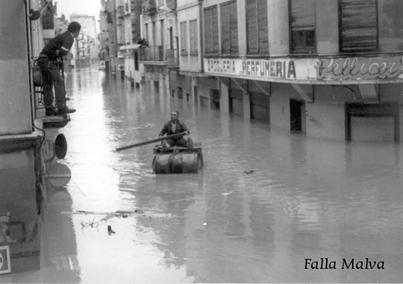
This link contains a photographic reportage of "Pantana" (the name by which is called this flood in Valencia realized by the falla plaza Malva  from Alcira (www.fallamalva.com)


picture of the flood, taken from the above link

BREAK OF THE TOUS DAM October 20, 1982 (Part 1)

On October 20, 1982, as a result of torrential rains caused by the cold drop, originated the worst flood in the history of Spain. Affecting Jucar basin that were more intense in the Valencia and Murcia.


On the night of 19 October, heavy rains began extending along the next day exceeding 600mm. Upstream Tous Swamp.
The river Jucar (Xuquer in Valencia, that comes from Arabic and its translation is the devastating) as it passes through the swamp of Tous, grew so that the weak walls and the lack of qualified personnel to hazardous situations in the dam joined inability to open the floodgates (because of the human factor) caused water to overflow the dam, and even when they got to open the floodgates, the amount of water was greater than the capacity of these. So finally broke down the dam. Causing a flood of 16,000 cubic meters per second, which devastated the regions of the Riera Alta and Riera Baja.


The populations most immediate to the dam came to have in their streets 8 meters high of water, such as Sumacàrcer, Beneixida or Gavarda.
The virulence of the water caused severe structural damage to most buildings, that's why Beneixida and Gavarda moved to higher ground, but Sumacàrcer remains in the same place.


This link contains a photographic reportage of "Pantana" (the name by which is called this flood in Valencia realized by the falla Plaza Malva from Alcira  (www.fallamalva.com)


picture of the flood, taken from the link above

30th ANNIVERSARY OF THE BROKEN OF THE TOUS DAM


Today October 20 marks the 30th anniversary of the breaking of the Tous dam, located in the region of the Riera Alta in the province of Valencia.
Suffering the worst flood in Spain.
Because of heavy rains due to the cold drop of 1982, the Tous dam (located between the towns of Tous and Millares) grew up to never known limits, exceeding the capacity of the dam and the responsible engineer.
Finally the dam gave way, flooding the whole region of the Riera Alta with maximum heights of 8 meters of water in the streets of some towns.


The old dam with a capacity of 80 cubic hectometers, could not withstand the pressure of the river Jucar (Xuquer in Valencian, name given by the Arabs who inhabited the Valencian Community, which translates as the devastating).
After the flood the dam was rebuilt with a current capacity of 340.4 cubic hectometers, modern sensors and with caution to reach these dates with minimum water.

This link contains a photographic reportage of "Pantana" (the name by which is called this flood in Valencia made ​​by the falla plaza Malva  from Alcira (www.fallamalva.com)


flood photo, taken from the Above link

sábado, 14 de julio de 2012

THE TURIA RIVER after the flood of 1957

After the last flood of 1957, which marks can be seen on plates of various streets in Valencia, it was decided to divert the final stretch of its course to prevent new flooding.
There were several plans for the deviation:
-The plan north near Alboraya down the ravine of Carraixet.
-By the Albufera
-Another option was to make his mouth wider and enhance its margins.
-Finally it was decided to do the so-called the South Plan, creating a major new channel that led up near Pinedo. With dimensions that ensure that no overflow again (as it has been so far).

In 1958 the project was approved by the government of Spain, in 1961 established funding guidelines and in February 1965 was the beginnig of the works.
As a curiosity that water can be seen at the end of the plan South is sea water and no from the river.

This created a new problem, what to do with the old riverbed of the Turia?


As the brilliant original idea was to make it an urban highway that crossed the city, fortunately the people of Valencia went to the streets en masse to claim it as green space for the entire city. It was one of The biggest ever protests (in Valencia) that more people gathered, along the protests made ​​against building in the Albufera and against the war in Iraq.
The park of Turia, has about 10 kilometers long with about 110 hectares of space and its central section was inaugurated in 1986.

The park of Turia, going from the current Bioparc zooin the park de Cabecera (built a few years ago) to the City of Arts and Sciences. From there, the passage is closed and turned into a zone of highly contaminated wastewater. Until enter into the Port of Valencia where it disappears.
The area around the Palau de la musica was designed by renowned architect Ricardo Bofill (father), where most of the budget were spending thankfully, as later, instead of following urbanizing in modernistic way, that area is also recognized for having palm and orange trees, it was decided to create a Mediterranean forest (cheaper than the other) where pines predominate. Gradually all areas have been overhauled.
Parks currently exceeds others parcs in Paris or Madrid and from another cities.


If I have not discounted, the stretch of the old river bed has 23 bridges (between for pedestrians and for traffic)


picture from the inside of the old riverbed of the Turia made by me